
197 posts
- , , - . 170 , . , 11 . , . , .


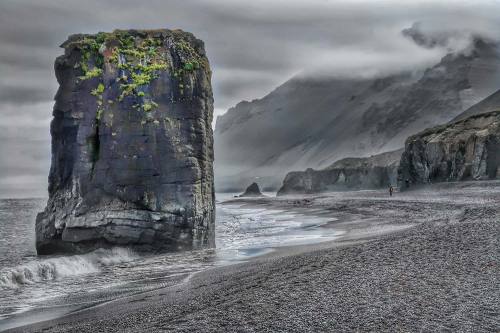
Каньоны Кок-Мойнок – это живописные и уникальные образования природы, расположенные в Киргизии, в аильном округе Тонского района Иссык-Кульской области. Они находятся в 170 км к востоку от столицы республики, г. Бишкека, или в 11 км к западу от г. Балыкчы, и являются частью Боомского ущелья. Название каньонов происходит от одноименного села, которое находится поблизости.
Характеристики каньонов впечатляют: это вымытые водой скальные породы гор, которые формировались десятки, а возможно, и сотни тысяч лет, создавая живописные узоры на скалах. В ущелье можно увидеть десяток каньонов с разной протяженностью, глубиной и шириной.Иногда они образуют небольшие пещеры и тупики. Подножье каньонов расположено на высоте 1500 метров над уровнем моря, а верхняя точка – от 1650 до 1700 метров над уровнем, что создает средний перепад высот в 150-200 метров. Окись железа в почве придает каньонам характерный оранжевый цвет.
Каньоны Кок-Мойнок являются уникальным природным явлением, а так же это отличное место для прогулок и фотосессий на фоне замысловатых природных скульптур. Здесь часто меняется погода, поэтому стоит брать с собой куртку, даже летом. Однако стоит помнить о возможности обвалов скальной породы и быть предельно аккуратным и внимательным во время посещения.
The Kok-Moinok Canyons are picturesque and unique natural formations located in Kyrgyzstan, in the ayil district of the Ton district of the Issyk-Kul region. They are located 170 km east of the capital of the republic, Bishkek, or 11 km west of Balykchy, and are part of the Boom Gorge. The name of the canyons comes from the village of the same name, which is located nearby.
The characteristics of the canyons are impressive: these are water-washed mountain rocks that have been forming for tens, and perhaps hundreds of thousands of years, creating picturesque patterns on the rocks. In the gorge, you can see a dozen canyons of varying length, depth and width. Sometimes they form small caves and dead ends. The foot of the canyons is located at an altitude of 1,500 meters above sea level, and the highest point is from 1,650 to 1,700 meters above sea level, which creates an average difference in altitude of 150-200 meters. Iron oxide in the soil gives the canyons a characteristic orange color.
The Kok-Moinok Canyons are a unique natural phenomenon, and they are also a great place for walks and photo sessions against the backdrop of intricate natural sculptures. The weather here often changes, so it is worth taking a jacket with you, even in summer. However, it is worth remembering the possibility of rock falls and being extremely careful and attentive during the visit.
Источник://t.me/borderlesstravel,/www.getyourguide.ru/bishkek-l1420/otkroite-dlia-sebia-sut-kan-onov-kok-moinok-t537113/, //pikabu.ru/story/kanonyi_kokmoynok_v_kyirgyizstane_i_vesyolyiy_pyos_6516695,//35photo.pro/tags/,//yandex.ru/maps/org/kanyon_kok_moynok/133351802586/gallery/?ll=76.585416%2C42.090184&photos %5Bbusiness%5D=133351802586&z=9,/dwc.kg/places/kanony-kok-mojnok/,/pikabu.ru/story/skazochnyie_kanonyi_kokmoynok_kyirgyizstan_6100470,/wandermore.ru/country/kyrgyzstan/kok-moynok, //www.lets-travel.asia/places/ushchele-kok-moynok.
-
 dream-world-universe liked this · 1 year ago
 -
 free0spirit liked this · 1 year ago
 -
 futurequeensmusic liked this · 1 year ago
 -
 pink-hedgehog-cactus reblogged this · 1 year ago
 -
 leontinrau liked this · 1 year ago
 -
 kingjr007 reblogged this · 1 year ago
 -
 oxbodies liked this · 1 year ago
 -
 meowdogbite liked this · 1 year ago
 -
35-erdogan-35 liked this · 1 year ago
-
 yourwhereorwhen liked this · 1 year ago
 -
 lovethemfiercely liked this · 1 year ago
 -
 htn-11-11 liked this · 1 year ago
 -
 goshminherz liked this · 1 year ago
 -
 raposasworld liked this · 1 year ago
 -
 zacharylee liked this · 1 year ago
 -
 uniquestarsworld liked this · 1 year ago
 -
 aria-diary liked this · 1 year ago
 -
 relaxationmusicc liked this · 1 year ago
 -
 asahi-yamane-art liked this · 1 year ago
 -
 abdalla-23 liked this · 1 year ago
 -
nopride-noshame reblogged this · 1 year ago
-
 elegantpersoncreation liked this · 1 year ago
 -
 musicandgallery liked this · 1 year ago
 -
 turkeyblogblr liked this · 1 year ago
 -
 kojiarakiartworks liked this · 1 year ago
 -
 skyscrapes-landscapes liked this · 1 year ago
 -
 king-of-roses-world liked this · 1 year ago
 -
 ness69sblog liked this · 1 year ago
 -
 silvio-jr liked this · 1 year ago
 -
 joaopinto liked this · 1 year ago
 -
 esamnoor liked this · 1 year ago
 -
 j-trofi liked this · 1 year ago
 -
 europeposts liked this · 1 year ago
 -
 thelostdreamsthings liked this · 1 year ago
 -
 hansdurrer liked this · 1 year ago
 -
dighowtheydothat liked this · 1 year ago
-
 bigwide liked this · 1 year ago
 -
 paddy0121 liked this · 1 year ago
 -
 bobyala13 liked this · 1 year ago
 -
 sergioguymanproust liked this · 1 year ago
 -
 plantinabelcher liked this · 1 year ago
 -
 b3gr8w0n reblogged this · 1 year ago
 -
 ted-blogs-blog liked this · 1 year ago
 -
 erabesteira liked this · 1 year ago
 -
 13olgablogpost liked this · 1 year ago
 -
 huseyinoktensblog liked this · 1 year ago
 -
 genunchiilumii liked this · 1 year ago
More Posts from Vestaignis


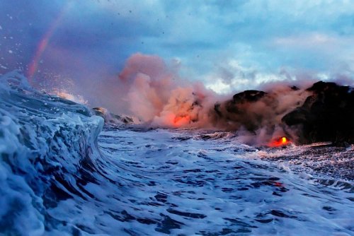


Извержение вулкана Килауэа: встреча двух стихий.
Вулкан Килауэа находится на Большом острове Гавайского архипелага и занимает почти 14% его территории.Килауэа - самый молодой из наземных гавайских вулканов (США) и один из самых активных действующих вулканов на Земле. Высота Килауэа - 1247 метров над уровнем моря, его основание уходит на дно Тихого океана на глубину около 5 км.
Последнее извержение Килауэа было в 1983 году и продолжается по настоящее время. Килауэа считается местом обитания Пеле — гавайской богини вулканов. По ее имени названы некоторые лавовые образования, например, «слезы Пеле» (маленькие капли лавы, которые студятся на воздухе и принимают фигуру слезы) и «волосы Пеле» (тонкие нити вулканического стекла обсидиана, возникающие в итоге быстрого остывания лавы при стекании в океан).
Профессиональная спортсменка Элисон Тил стала первой девушкой, решившей устроить экстремальный серфинг возле извергающегося вулкана. Бурлящие потоки лавы стекают прямо в океан, в то самое место, где и решила поплавать спортсменка. Тут стоит быть предельно осторожным и оставаться на чеку, ведь скорость, с которой движется раскаленная лава, может составлять несколько метров в секунду, а температура ее колеблется в районе 500–1200° C — этого с лихвой хватит, чтобы моментально свариться заживо.
За Килауэа круглосуточно наблюдают десятки специалистов со всего мира. На кадрах с Гавайев – огненные потоки лавы стекают со склонов вулкана прямо в Тихий океан. По утверждению ученых, при контакте раскаленной субстанции и воды брызги лавы взлетают на десятки метров. Удивительное природное явление привлекает к вулкану Килауэа туристов, которые желают увидеть столкновение стихий вживую. Однако геологи не рекомендуют приближаться к вулкану, поскольку тот может оказаться непредсказуемым.
Kilauea Volcano Eruption: A Meeting of Two Elements.
Kilauea Volcano is located on the Big Island of the Hawaiian archipelago and occupies almost 14% of its territory. Kilauea is the youngest of the Hawaiian land volcanoes (USA) and one of the most active volcanoes on Earth. Kilauea is 1,247 meters above sea level, its base goes to the bottom of the Pacific Ocean to a depth of about 5 km.
The last eruption of Kilauea was in 1983 and continues to this day. Kilauea is considered the home of Pele, the Hawaiian goddess of volcanoes. Some lava formations are named after her, for example, "Pele's tears" (small drops of lava that cool in the air and take the shape of a tear) and "Pele's hair" (thin threads of volcanic obsidian glass that appear as a result of the rapid cooling of lava as it flows into the ocean).
Professional athlete Alison Teel became the first girl to try extreme surfing near an erupting volcano. Bubbling lava flows straight into the ocean, the very place where the athlete decided to swim. Here you should be extremely careful and stay on guard, because the speed at which the hot lava moves can be several meters per second, and its temperature fluctuates around 500–1200° C — this is more than enough to instantly boil alive.
Kilauea is monitored around the clock by dozens of specialists from all over the world. In the footage from Hawaii, fiery lava flows flow from the slopes of the volcano straight into the Pacific Ocean. According to scientists, when the hot substance comes into contact with water, splashes of lava fly up tens of meters. An amazing natural phenomenon attracts tourists to the Kilauea volcano who want to see the clash of the elements live. However, geologists do not recommend approaching the volcano, as it may prove unpredictable.
Источник: /travelask.ru/blog/posts/4045-zaplyv-s-lavoy-na-gavayyah, //gsavia.com/uncategorized/gavajskie-vulkany-nacionalnyj-park.html, /ru.pinterest.com/pin/9499849187484206/,/loveopium.ru/severnaya-amerika/izrygayushhij-vulkan-kilauea.html,/masterok.livejournal.com /105805.html,//t.me/+E4YBiErj0A8wOGUy,/onznews.wdcb.ru/jul16/info_160726.html,/gorets-media.ru/news/3717.
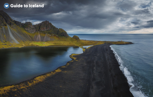
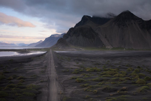

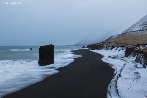
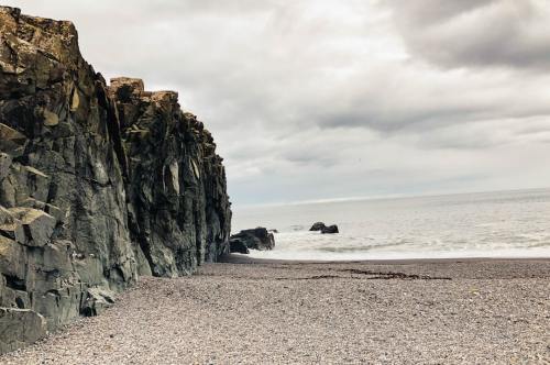
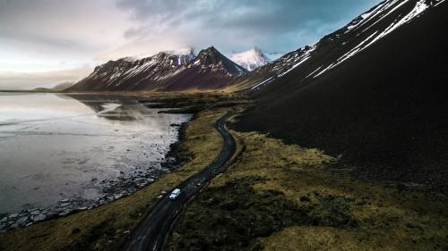
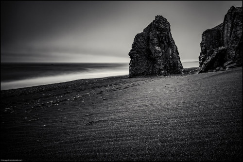
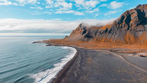
Черный пляж Фаускасандур расположен на южном побережье Исландии, недалеко от небольшого городка Вик-и-Мюрдал. Этот регион характеризуется суровым вулканическим ландшафтом, который является результатом миллионов лет геологической деятельности. До пляжа можно добраться по национальной дороге № 1, известной как Хрингвегур, которая проходит вокруг всей Исландии, соединяя самые важные города и туристические достопримечательности.
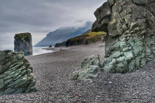
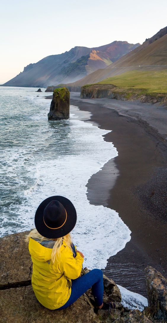
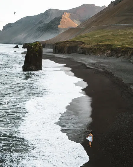
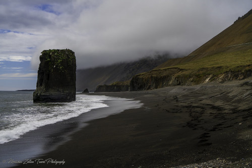
Регион, в котором расположен Фаускасандур, отличается исключительным ландшафтным разнообразием. Рядом с пляжем расположены величественные скалы, вулканические скальные образования и многочисленные пещеры. Одной из самых впечатляющих особенностей ландшафта является гора Рейнисфьялль, которая возвышается над пляжем, откуда открывается захватывающий вид на океан и окрестности.
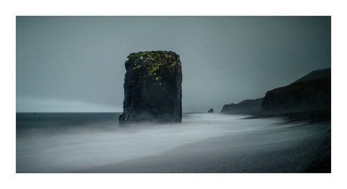
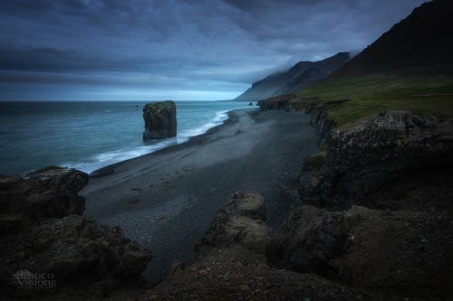
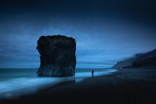
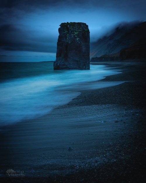
Черный песок пляжа состоит из измельченного базальта, образовавшегося в результате извержений вулканов. Базальтовый песок чрезвычайно мелкий и мягкий, благодаря чему пляж кажется почти сюрреалистическим. Рядом с пляжем можно увидеть впечатляющие базальтовые колонны Рейнисдрангар, которые по легенде являются окаменевшими троллями. Пляж Фаускасандур так же примечателен своим черным песком и огромным монолитом, возвышающимся над его берегом. Почти прямоугольная гигантская скала выглядела неуместно, выступая как недостающая часть окружающих горных оснований. С ее вершиной, покрытой зеленой листвой, которая сползает по скалистым склонам, это естественное скальное образование добавляет уникальный элемент темной береговой линии.Также стоит упомянуть поразительный контраст между белыми изломами в волнах и черным песком.
В целом, уникальный вид Фаускасандура делает его особенно идеальным местом для фотографов. Фаускасандур можно посещать круглый год. Летом, когда погода хорошая, а световой день достигает своей максимальной длины, посетители могут наслаждаться долгими прогулками по песчаному берегу, наблюдая за волнами, разбивающимися о темный песок под полуночным солнцем в течение 20 часов в день. Так же в теплый сезон окрестности становятся зеленее и ярче, а зима подчеркивает завораживающий контраст между белым снегом и черным песком.
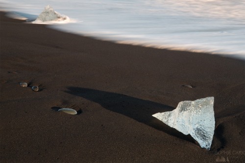
The black beach of Fauskasandur is located on the south coast of Iceland, near the small town of Vik y Myrdal. This region is characterized by a rugged volcanic landscape, which is the result of millions of years of geological activity. The beach can be reached via National Road 1, known as Hringvegur, which runs around the entire country of Iceland, connecting the most important cities and tourist attractions.
The region in which Fauskasandur is located has an exceptional landscape diversity. Near the beach there are majestic cliffs, volcanic rock formations and numerous caves. One of the most impressive features of the landscape is the mountain Reynisfjall, which rises above the beach, offering breathtaking views of the ocean and the surrounding area.
The black sand of the beach consists of crushed basalt, formed by volcanic eruptions. Basalt sand is extremely fine and soft, making the beach seem almost surreal. Near the beach, you can see the impressive basalt columns of Reynisdrangar, which according to legend are petrified trolls. Fauskasandur beach is also notable for its black sand and the huge monolith that towers over its shore. The almost rectangular giant rock looked out of place, protruding as a missing part of the surrounding mountain bases. With its top covered in green foliage that creeps down the rocky slopes, this natural rock formation adds a unique element to the dark coastline. Also worth mentioning is the striking contrast between the white breaks in the waves and the black sand.
Overall, Fauskasandur's unique appearance makes it an especially ideal place for photographers. Fauskasandur can be visited all year round. In the summer, when the weather is fine and the daylight hours are at their longest, visitors can enjoy long walks along the sandy shore, watching the waves crash against the dark sand under the midnight sun for 20 hours a day. Also, during the warm season, the surroundings become greener and brighter, and winter highlights the mesmerizing contrast between the white snow and black sand.
Источник://t.me/divo_planeta,/guidetoiceland.is/travel-iceland /drive /fauskasandur-black-sand-beach,/park4night.com/en/place/111259, //sophiecarr.blogspot.com/2018/04/iceland-14-day-7-from-wonderful. html,/www.hatlastravel.com/destination/Iceland/?category=Highland &place=Fauskasandur#pictures,/sandee.com/iceland/east-region/ starmyri/fauskasandur,/ru.gancarczyk.com/Черная-площадь-Фаускасандур-доступ-автостоянка-достопримечательности/, /www.irishroots.pl/czarna-plaza-fauskasandur.htm , /35photo.pro / tags/fauskasandur/.

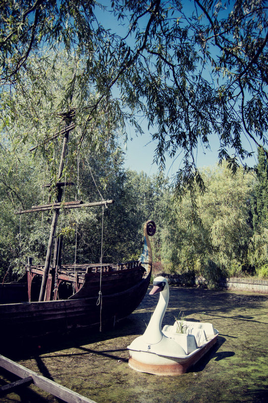


Одна из альтернативных достопримечательностей Берлина - Шпреепарк, заброшенный парк аттракционов с трагической судьбой.
Парк открыли в 1969 году на берлинском полуострове Плэнтервальд, и до 1989 года он оставался единственным парком развлечений в ГДР. Для учредителей было важно, что место несет не только увеселительный, но и образовательный характер.Так появилось название “Культурный парк” — Kulturpark Plänterwald. Кроме катания на аттракционах и американских горках в Kulturpark можно было сходить на концерт или танцевальный вечер.После объединения Германии стало понятно: старому парку не место в новом Берлине. Берлинский сенат организовал тендер среди подрядчиков, чтобы превратить уже не модный Культурный парк в настоящую мекку развлечений по лучшим западным образцам: в берлинский Диснейленд.
Новыми владельцами парка стала семья Витте. Они переименовали место в Spreepark («Парк у реки Шпрее»), закупили огромное количество новых аттракционов, ввели плату за вход в парк и устроили реорганизацию. Многие аттракционы они привезли из разорившегося французского парка Мираполис, в том числе знаменитую железную дорогу и карусель с чашками, на которых был изображен старый талисман компании Nesquik — кролик Groquik. Из Франции в Германию также переехали трех- и четырехметровые динозавры и два мамонта: огромные фигуры сразу стали в Шпреепарке любимцами публики. Стегозавр, тираннозавр, апатозавр, стиракозавр с товарищами встречали гостей у входа в парк, возвышались над деревьями и приводили в восторг посетителей.
До 2000 года дела у Шпреепарка шли неплохо. Но цена билетов постоянно росла, при этом мест для парковки не хватало, а сами аттракционы стремительно старели. Число посетителей упало с полутора миллиона до четырехсот тысяч, у парка появились долги, и компанию-учредителя признали банкротом. И в 2001 году парк закрылся. Но на владельце Spreepark по-прежнему висел долг в € 11 млн, поэтому он решился…открыть новый парк! На этот раз в Перу, для чего он перенаправил туда шесть своих аттракционов. Но и там дело не пошло.
Сейчас в парке остались многие аттракционы, на которых можно сделать интересные фотографии. Самый большой аттракцион – колесо обозрения, до сих пор крутится благодаря ветру. Также здесь есть американские горки, ракеты, машинки. С марта 2019 года в Шпреепарке проводятся организованные экскурсии (на немецком и английском языках). Посетители могут ознакомиться с историей парка, осмотреть еще сохранившиеся аттракционы, постройки. Их продолжительность – 1,5 часа. Помимо этого, парк стал местом проведения различных выставок уличного искусства, вечеров и встреч с художниками и музыкантами.
One of Berlin's alternative attractions is Spreepark, an abandoned amusement park with a tragic fate.
The park opened in 1969 on Berlin's Planterwald peninsula, and until 1989 it remained the only amusement park in the GDR. It was important to the founders that the place not only had an entertaining, but also an educational character. This is how the name "Culture Park" - Kulturpark Plänterwald - appeared. In addition to riding the rides and roller coasters, you could go to a concert or dance evening in Kulturpark. After the unification of Germany, it became clear: the old park had no place in the new Berlin. The Berlin Senate organized a tender among contractors to turn the no longer fashionable Kulturpark into a real mecca of entertainment according to the best Western examples: Berlin Disneyland.
The Witte family became the new owners of the park. They renamed the place Spreepark, bought a huge number of new rides, introduced an entrance fee and reorganized the park. They brought many rides from the bankrupt French park Mirapolis, including the famous railway and the carousel with cups, which depicted the old mascot of the Nesquik company - the Groquik rabbit. Three- and four-meter dinosaurs and two mammoths also moved from France to Germany: huge figures immediately became favorites of the public in Spreepark. Stegosaurus, tyrannosaurus, apatosaurus, styracosaurus and friends greeted guests at the entrance to the park, towered over the trees and delighted visitors.
Until 2000, Spreepark was doing well. But the price of tickets was constantly rising, there was a shortage of parking spaces, and the rides themselves were rapidly aging. The number of visitors dropped from one and a half million to four hundred thousand, the park got into debt, and the parent company was declared bankrupt. And in 2001, the park closed. But the owner of Spreepark still had a debt of € 11 million, so he decided to… open a new park! This time to Peru, for which he redirected six of his rides there. But things didn’t work out there either.
Now the park still has many rides on which you can take interesting photos. The largest ride is the Ferris wheel, which still spins thanks to the wind. There are also roller coasters, rockets, cars. Since March 2019, Spreepark has been offering organized tours (in German and English). Visitors can learn about the history of the park, see the remaining rides and buildings. They last 1.5 hours. In addition, the park has become a venue for various street art exhibitions, evenings and meetings with artists and musicians.
Источник:/stalkers.info/zabroshennyj-park-attraktsionov-spreepark/, //www.gavailer.ru/journal/685.html,/ru-travel.livejournal.com / 27731230.html,/andrreas.livejournal.com/756034.html,/berlin24.ru/ru/news/novosti-germanii-segodnja-v-novostjah/6733-urban-trip-v-berline.html,/directfromberlin.wordpress.com/2018/09/14/abandoned-amusement-park-spreepark-in-berlin/,/samokatus.ru/shpreepark-ot-rascveta-do-zakata/.


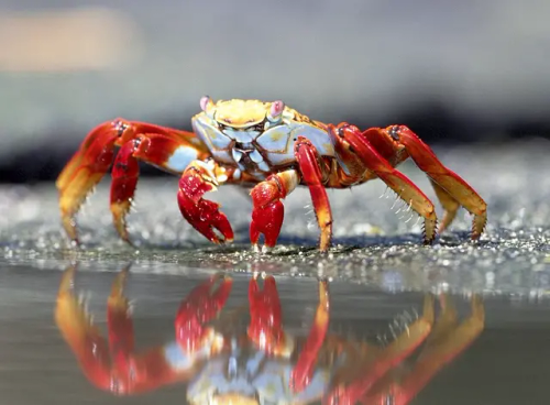
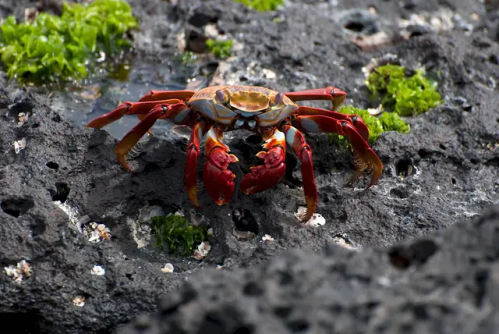


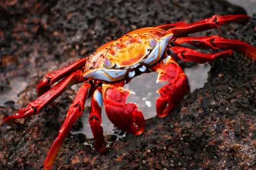


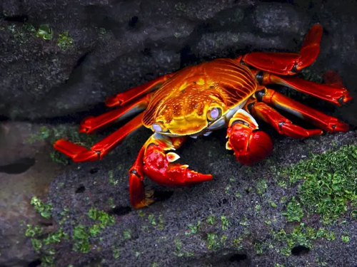

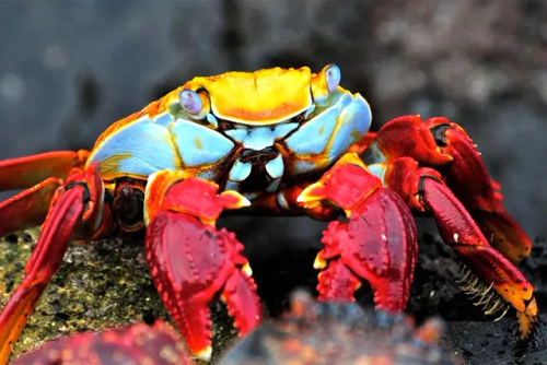
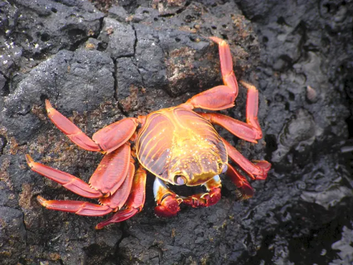
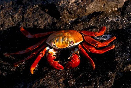


Красный скальный краб (лат. Grapsus grapsus) или «Sally Lightfoot Crab» – десятиногое ракообразное из семейства Grapsidae. Салли Лайтфут — это небольшой, с достигающим 8 сантиметров панцирем, вертикально сплюснутый краб с общей окраской от коричневого до оливково-коричневого цвета и полосами от коричневого до желтого или оранжевого цвета на ногах. Детёныши красного скального краба окрашены в чёрный цвет.
Вид был впервые описан Карлом Линнеем ещё в 1758 году, но до 1990 года этих крабов относили к виду Grapsus adscensionis, обитающему в восточной части Атлантического океана. Животное обитает на тихоокеанском побережье и Центральной Америки, Мексики и Южной Америки до северного Перу; многочисленны на Галапагосских островах. Кроме того, эти крабы водятся в Атлантическом океане на отдаленной группе островов Сан-Педру-и-Сан-Паулу.
Красный скальный краб отличается большой проворностью и ловкостью, поэтому его очень трудно поймать. Он очень резво перемещается по твердой поверхности и может бегать по почти вертикальным утесам. Салли Лайтфут обладает уникальной способностью плотно всем телом прижиматься к скалам с такой силой, что его не может оторвать даже сильный прибой. Нередко его можно увидеть отдыхающим на камнях вместе с морскими игуанами. Иногда представители данного вида помогают ящерицам избавиться от поселившихся на их коже паразитов.
Красные крабы бурно реагируют на приближение любых хищников. При малейшей опасности они спасаются бегством. Они постоянно резко меняют направление бега, что в большинстве случаев сбивает преследователей с толку.Животное также отличается умением быстро регенерировать утраченные конечности, оставив их на съедение хищникам. Днем ракообразные прячутся в скальных расщелинах или норах. Во время ночного отлива они разгуливают по обнажившемуся дну в поисках пищи. Питаются Grapsus grapsus водорослями и падалью, выброшенными на берег морем. В целом они ведут полуводный образ жизни.
Старые особи живут в гордом одиночестве, а молодь предпочитает собираться порой весьма многочисленными группами.
The red rock crab (lat. Grapsus grapsus) or "Sally Lightfoot Crab" is a decapod crustacean of the family Grapsidae. Sally Lightfoot is a small, with a shell reaching 8 centimeters, vertically flattened crab with a general coloration from brown to olive-brown and stripes from brown to yellow or orange on the legs. The young of the red rock crab are colored black.
The species was first described by Carl Linnaeus in 1758, but until 1990 these crabs were classified as the species Grapsus adscensionis, which lives in the eastern part of the Atlantic Ocean. The animal lives on the Pacific coast and Central America, Mexico and South America to northern Peru; numerous on the Galapagos Islands. In addition, these crabs are found in the Atlantic Ocean on the remote group of islands of Sao Pedro and Sao Paulo.
The red rock crab is very agile and dexterous, so it is very difficult to catch. It moves very quickly on a hard surface and can run along almost vertical cliffs. Sally Lightfoot has a unique ability to press its entire body tightly to the rocks with such force that even a strong surf cannot tear it away. It can often be seen resting on the rocks with marine iguanas. Sometimes representatives of this species help lizards get rid of parasites that have settled on their skin.
Red crabs react violently to the approach of any predators. At the slightest danger, they flee. They constantly sharply change the direction of their run, which in most cases confuses their pursuers. The animal is also distinguished by the ability to quickly regenerate lost limbs, leaving them to be eaten by predators. During the day, crustaceans hide in rock crevices or burrows. During the night low tide, they walk along the exposed bottom in search of food. Grapsus grapsus feed on algae and carrion washed up on the shore by the sea. In general, they lead a semi-aquatic lifestyle.
Old individuals live in proud solitude, and young ones prefer to gather in sometimes very large groups.
Источник:/t.me/+E4YBiErj0A8wOGUy,/zooclub.org.ua/kraby/krasnyj-skalnyj-krab.html, ://ru.wikipedia.org/wiki/Grapsus_grapsus, //www.lookphotos.com/en/images/70133765-Sally-Lightfoot-Crab-Grapsus-grapsus-Galapagos-Islands-Ecuador, /sotni.ru/kraby-krasivye-kartinki/.


Яркие краски осени и первых дней зимы в Патагонии. Bright colors of autumn and the first days of winter in Patagonia.
Источник:t.me/+HLoqW4OcT5VjZjM6,/35photo.pro/photo_1792144/,/35photo.pro/alexey2014/,/35photo.pro/photo_7582177/,//35photo.pro/photo_1750007/,/35photo.pro/photo_2306165/,/35photo.pro/petrus/,//pikabu.ru/story/osen_v_patagonii_6811020,//35photo.pro/runova2006/, /aleksphoto.livejournal.com/14357.html,/pikabu.ru/story/osennie_kraski_patagonii_argentina_8329982,/35photo.pro/olegrest/, /35photo.pro / photo_3153033/.