1575 posts
Chapman's Peak Drive On The Atlantic Coast Between Hout Bay And Noordhoek In The Cape Peninsula In South
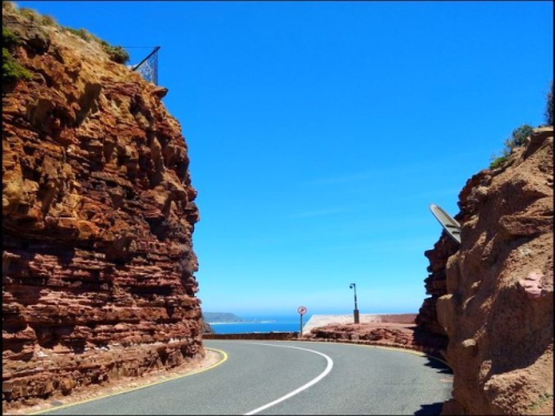
Chapman's Peak Drive on the Atlantic Coast between Hout Bay and Noordhoek in the Cape Peninsula in South Africa is one of the most spectacular marine drives in Africa and in the world. Chapman’s Peak Drive is affectionately known amongst locals as “Chappies” and is the must for anyone who is passionate about the majestic scenery of Cape Town and South Africa. Initially constructed during the WW1, this 9 km route with its 114 curves, skirts Chapman's Peak, the 590 m high southerly extension of Constantia Berg, and follows the rocky coastline to unfold breathtaking views in both directions. Car companies from all over the world like to shoot their commercials here.
------------------------------------------------------
Der Chapman’s Peak Drive ist eine neun Kilometer lange Küstenstraße auf der Kap-Halbinsel südlich von Kapstadt. Er schlängelt sich in 114 Kurven unmittelbar zwischen Meer und steilen Felswänden entlang von Hout Bay nach Noordhoek und führt über den Chapman’s Peak, einen 160 Meter hoch gelegenen Aussichtspunkt. Touristen und Einheimische halten häufig an den Aussichtspunkten entlang dieser Straße an, die einen spektakulären Blick auf die Hout Bay, den Sentinel Peak und die Umgebung sowie auf die unberührten Sandkilometer am Noordhoek Beach bieten. Autohersteller aus aller Welt drehen hier gerne ihre Werbespots.


-
 squinty-cat liked this · 1 year ago
 -
 travelfreaksworld liked this · 2 years ago
 -
 roelia-blog liked this · 4 years ago
 -
 mystarryeyesareblinding liked this · 4 years ago
 -
 enjoying-life-now reblogged this · 4 years ago
 -
 aladwanivip liked this · 4 years ago
 -
 hippokamp liked this · 4 years ago
 -
 perfectlyglitterypeach liked this · 4 years ago
 -
 logi1974 liked this · 4 years ago
More Posts from Logi1974
The Eastern Cape game reserves are malaria-free, easily accessible and home to the Big 5. Their diverse landscapes and wildlife, as well as their excellent lodges, have made these reserves hugely popular. Just a short drive from the Garden Route, they're a wonderful to cap off a visit to this magical region.
--------------------------------------
Die Wildreservate am Ostkap sind frei von Malaria, leicht zugänglich und beherbergen die Big 5. Ihre vielfältigen Landschaften und Wildtiere sowie ihre hervorragenden Lodges haben diese Reservate sehr beliebt gemacht. Nur eine kurze Fahrt von der Garden Route entfernt, sind sie ein wunderbarer Abschluss eines Besuchs in dieser magischen Region.


Steve Braine has been involved with ornithology and natural history within Namibia from a very young age, contributing invaluable data to Namibian Ornithology and natural history. He guided many specialized eco- and ornithological tours throughout Namibia.
During the past ten years Steve and his wife have travelled extensively doing birding and photography. Steve has passed his on-going enthusiasm and love for natural history to his two sons who now assist with birding, wildlife and photographic tours.
---------------------------------------------------------
Steve Braine hat sich bereits in jungen Jahren mit Ornithologie und Naturgeschichte in Namibia befasst und wertvolle Daten zur namibischen Ornithologie und Naturgeschichte beigetragen. Er führte viele spezialisierte ökologische und ornithologische Touren durch Namibia.
In den letzten zehn Jahren sind Steve und seine Frau viel gereist, um Vögel zu beobachten und zu fotografieren. Steve hat seine anhaltende Begeisterung und Liebe zur Natur an seine beiden Söhne weitergegeben, die jetzt bei Vogelbeobachtungen, Wildtieren und Fototouren behilflich sind.


Das Nguni-Rind stand Pate. Wie der Umriss seines Kopfes mit den weit ausladenden Hörnern, liegen die Chalets der neuen Etosha King Nehale Lodge in der spektakulären Landschaft der Andoni-Ebene. Es ist nur ein Katzen-, oder sagen wir besser: ein Löwensprung zum nördlichsten Tor des Etosha-Nationalparks, dem Eintritt ins Paradies der wilden Tiere. Artesische Quellen locken Herden von Gnus, Springböcken, Antilopen und Konsorten in das endlose Grasland.
Strikingly set on the Andoni plains, one kilometre from Etosha National Park’s King Nehale gate is new Etosha King Nehale Lodge. The lodge effortlessly portrays the shape of an Nguni cattle head, with chalets stunningly furrowed to the north and south, from the central area like a bull’s horns. Artesian sources lure herds of wildebeest, springboks, antelopes and companions into the endless grasslands.


Kolmanskop's name derives from a driver, Johnny Coleman who once was lost and overnighted next to this place. The name means “Coleman’s Hill” in Afrikaans (German: Kolmannskuppe). Abandoned ghost town ruins are scattered in the Namib Desert 10 km east of the coastal town of Lüderitz. Diamonds were discovered here in 1908 by Zacharias Lewala, a Lüderitz - Keetmanshoop railway employee. Kolmanskop grew out of the diamond boom. The region was administered by Germany at the beginning of the century and the town reflected this in its character. It was said of the Germans that only after they had finished building the pub and the skittle alley, their favorite form of relaxation, did they start looking for suitable plots to build their houses. Fresh water was bought in by rail from 120 km away and pumped into storage tanks. World War I interrupted mining operations. The town’s demise was accelerated by the discovery in 1928 of the richest diamond-bearing deposits ever known on the beach terraces 270 km south of Kolmanskop, near the Orange River mouth. Many of the town’s inhabitants joined the rush to the south, leaving their homes behind. Kolmanskop retained some importance as a supply depot for other mining operations, including those on the Orange River. The last families finally deserted the town in 1956.
----------------------------------------------------------
Kolmanskops Name leitet sich von einem Fahrer ab, Johnny Coleman, der sich verirrte und hier übernachtete. Der Name bedeutet auf Deutsch: Kolmannskuppe. Die Ruinen der verlassenen Geisterstadt sind in der Namib-Wüste, 10 km östlich der Küstenstadt Lüderitz, verstreut. Diamanten wurden hier 1908 von Zacharias Lewala, einem Eisenbahnmitarbeiter von Lüderitz - Keetmanshoop, entdeckt. Kolmannskuppe entstand aus dem Diamantenboom. Die Region wurde zu Beginn des Jahrhunderts von Deutschland verwaltet und die Stadt spiegelte dies in ihrem Charakter wider. Von den Deutschen hieß es, dass sie erst nach dem Bau der Bar und der Kegelbahn, ihrer bevorzugten Form der Entspannung, nach geeigneten Grundstücken für den Bau ihrer Häuser suchten. Frischwasser wurde aus 120 km Entfernung per Bahn eingekauft und in Lagertanks gepumpt. Der Erste Weltkrieg unterbrach den Abbau. Der Niedergang der Stadt wurde durch die Entdeckung der reichen diamanthaltigen Stätten im Jahr 1928 auf den Strandterrassen 270 km südlich von Kolmanskuppe, nahe der Mündung des Orangenflusses, beschleunigt. Viele Einwohner der Stadt schlossen sich dem Ansturm nach Süden an und ließen ihre Häuser zurück. Kolmannskuppe behielt eine gewisse Bedeutung als Versorgungsdepot für andere Bergbaubetriebe, einschließlich der am Orange River. Die letzten Familien verließen die Stadt 1956.


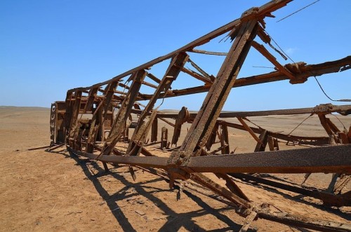
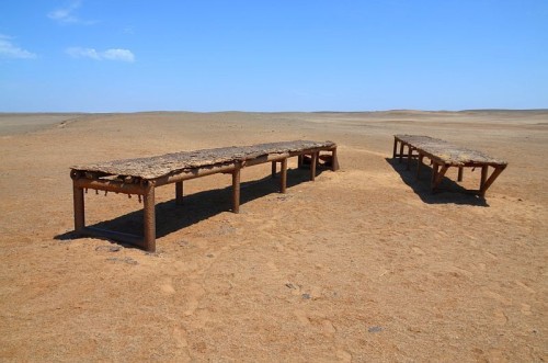
Abandoned oil rig near Toscanini, Skeleton Coast National Park, Namibia's West Coast: An abandoned oil drilling rig lost in the Namib Desert near Toscanini, was operational in the late 60's and early 70's. At the centre is V16 Caterpillar engine - the main power unit. A rig was erected by hopeful entrepreneurs long before Skeleton Coast National Park was proclaimed.
--------------------------------------------------
Verlassene Bohrinsel in der Nähe von Toscanini, Skeleton Coast National Park, Westküste Namibias: Eine verlassene Ölbohrinsel, die in der Namib-Wüste in der Nähe von Toscanini zurück gelassen wurde, war Ende der 60er und bis Anfang der 70er Jahre in Betrieb. Im Zentrum steht der V16 Caterpillar Motor - das Hauptaggregat. Lange bevor der Skeleton Coast National Park proklamiert wurde, wurde von hoffnungsvollen Unternehmern dieser Bohrturm errichtet.